Alta Via dei Parchi - 3D Maps 1.1
Free Version
Publisher Description
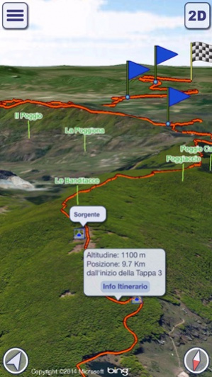
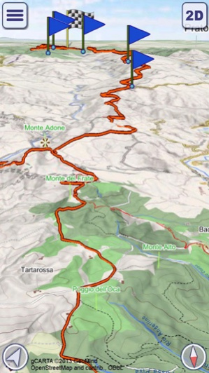
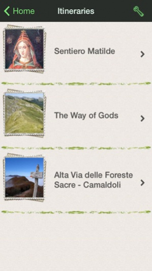
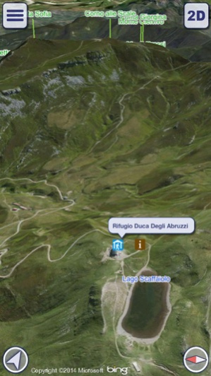
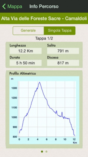
“Alta Via dei Parchi 3D” is the official mapping product of “Appennino e Verde – Regione Emilia Romagna” to support the hikers along the best itineraries of the Apennines, in an unspoiled countryside, in real contact with nature, culture and history. MAIN FEATURES - Highly detailed 3D terrain - Online and Offline modes - Pre-defined itineraries - GPS tracking - Name search (also in Offline mode) - Calculation of custom paths (routing) - Altimetry graph, travel times and statistics - Custom made gCARTA Topographic chart - Gyroscope features: GyroPilot and First Person View Alta Via dei Parchi 3D shows you high quality terrain details, 3D topographic maps and aerial images, with points of interest, natural attractions, trails and paths. The pre-defined itineraries show you the best hiking routes of the Apennines, with support information for your excursions; it also possible to build your own custom routes. Maps can be stored offline on your device, so you will always follow the best path, no matter if in the middle of the forest or at the top of a mountain. The three phases of the use of “Alta Via dei Parchi 3D”: 1)Before you go: plan your trip on the 3D map, check the best way points, discover the local attractions. Take a preview of your hike, or just fly over your favorite mountains with a virtual tour. 2)During your trip: record your GPS tracks, check your ascent rates and times, improve your hiking experience in “First Person View” mode, where “Alta Via dei Parchi 3D” uses your position and view direction to display what is in front of you, with the names of mountains, landmarks, etc.. 3)When you come back home: review your paths, share your saved tracks with your friends, save them for future use and check your stats information. WARNING Continued use of GPS running in the background can dramatically decrease battery life. AVAILABLE ITINERARIES - Sentiero Matilde - The Way of Gods - Alta Via delle Foreste Sacre – Camaldoli
Sep 27, 2014 Version 1.1 - Introduced synchronization of recorded tracks and routes among devices with the same iCloud account. Fixed bugs: - GPS recording could be suspended if the location remained the same for a certain time. - Elevation profile was not always calculated correctly. - Fixed other minor bugs.
About Alta Via dei Parchi - 3D Maps
Alta Via dei Parchi - 3D Maps is a free app for iOS published in the Recreation list of apps, part of Home & Hobby.
The company that develops Alta Via dei Parchi - 3D Maps is GeoMind. The latest version released by its developer is 1.1.
To install Alta Via dei Parchi - 3D Maps on your iOS device, just click the green Continue To App button above to start the installation process. The app is listed on our website since 2014-09-27 and was downloaded 7 times. We have already checked if the download link is safe, however for your own protection we recommend that you scan the downloaded app with your antivirus. Your antivirus may detect the Alta Via dei Parchi - 3D Maps as malware if the download link is broken.
How to install Alta Via dei Parchi - 3D Maps on your iOS device:
- Click on the Continue To App button on our website. This will redirect you to the App Store.
- Once the Alta Via dei Parchi - 3D Maps is shown in the iTunes listing of your iOS device, you can start its download and installation. Tap on the GET button to the right of the app to start downloading it.
- If you are not logged-in the iOS appstore app, you'll be prompted for your your Apple ID and/or password.
- After Alta Via dei Parchi - 3D Maps is downloaded, you'll see an INSTALL button to the right. Tap on it to start the actual installation of the iOS app.
- Once installation is finished you can tap on the OPEN button to start it. Its icon will also be added to your device home screen.
